
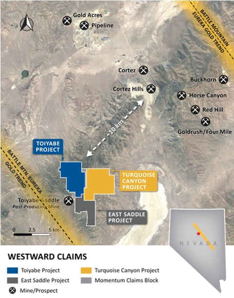
Westward Gold Inc. (CSE: WG, OTCQB: WGLIF, FSE: IM50) (“Westward” or the “Company”) is pleased to provide preliminary details surrounding planned 2024 exploration activities at the Company’s 100%-owned Toiyabe, Turquoise Canyon, and East Saddle Projects situated along the Cortez Trend (within the broader Battle Mountain – Eureka Gold Trend) in Lander County, NV (collectively, the “Properties”). Together, the Properties represent a newly-consolidated district-scale opportunity covering approximately 39 square kilometers of contiguous mining claims, a short distance away from some of Nevada’s most productive gold mining operations.
The Company has drawn from its considerable in-house expertise in Carlin-type gold exploration in formulating its strategy to systematically advance priority target areas, with the added benefit of broad-scale interpretations of data amalgamated from all three Properties. There is mounting evidence that Westward’s exploration ground contains many of the same key geological features that were identified at the nearby Cortez Hills Mine during its early-stage exploration (now operated by Nevada Gold Mines). These include dike-filled fault corridors, multiple compressional tectonic events, shallow gold mineralization in tandem with a second deeper zone (both open in several directions), and multiple horizons of favourable carbonate host rocks. Notably, Steven Koehler (Westward Technical Advisor) has been instrumental in the Company’s understanding of this important analogue, having been on the initial discovery team at Cortez Hills in the early 2000s.
2024 Exploration Program – Main Drivers of Future Success:
- Exceptional opportunity to apply proven, systematic exploration methods designed by a team of experts with Nevada discovery pedigree
- Multi-year land consolidation efforts have created a highly-compelling yet under-explored prospect with scale, only 10 km from the massive Cortez Mine Complex
- Exploration breakthroughs point to new robust target zones in classic Carlin geological, geophysical, and geochemical settings – including a 6 km-long corridor of interest (the “Hilltop Corridor”) which has never been drilled
- Westward will bolster these advancements with additional mapping, geochemical, and geophysical coverage, fine-tuning the best targets while mitigating risks, and will select the top contenders for drilling
Figure 1: Westward’s Consolidated Land Position (Cortez Trend)
Colin Moore, President & CEO, commented: “We’re on the hunt for a company-making discovery, and while there are no shortcuts in exploration, we’re extremely lucky to have a team of Carlin experts who have done it multiple times over and know the recipe. Improved data will lead to the highest-confidence targets, and we will be prepared to test these with drilling when capital markets conditions allow.”
Robert Edie, Vice President Exploration, added: “In an environment where exploration dollars are extremely valuable, we owe it to our shareholders to be highly systematic as it relates to target development. The suite of programs proposed in 2024 will enable us to evaluate and rank drilling prospects against one another based on the science, and we will select the areas with the strongest potential to host an economic gold deposit.”
Target Definition: Westward’s Detailed Geological Mapping Reveals Key Features
The structural setting at the Properties is complex, and a critical element of Carlin-type mineralizing systems. A detailed understanding of faults, compressional features such as folds and thrusts, and structural intersections on the Properties is essential to delineating the highest-priority target areas. The Company plans to expand upon its Anaconda-style mapping campaign and folio compilation, which began in 2022 at the Toiyabe Project and has already led to vastly improved geological models (see Figure 2 below).
Figure 2: Toiyabe Project – Inherited Geologic Map (Above) vs. Westward Mapping (Below)
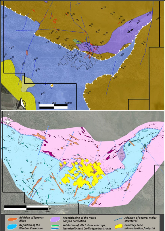
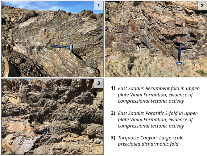
Several new igneous dikes were identified and mapped for the first time, with one set appearing to correlate to Eocene magmatism; these dikes are a key feature often associated with major Carlin-type gold deposits in Nevada. Structural intersections, and compressional tectonic features (e.g. folds and thrusts), are typically favourable depositional settings; this is the case at the nearby Cortez Complex where two separate and unique compressional events intersect, creating intense structural preparation of the ore-hosting rock formations. There is widespread evidence for similar compressional deformation on the Properties. Select examples are shown in Figure 3 below, with intensely-developed compressional structure in upper-plate siliciclastic rocks, indicative of the lower-plate carbonate rocks having experienced host-rock preparation.
Further definition of the regional structural footprint is essential to advancing the Company’s understanding of controls on gold mineralization. The mapping campaign will be one of several fundamental tools used to guide the Company towards the most promising structural intersections and damage zones to be tested with drilling.
Figure 3: Examples of Compressional Tectonic Features Observed on the Properties
Target Selection: Expanded Sampling Program to Fine-Tune Future Drilling
Westward will collect and analyze an additional 500 rock samples at the Properties, expanding upon the Company’s existing rock-chip dataset (Figure 4 below) by (i) increasing sample density in emerging target areas, and (ii) covering previously-unsampled portions of the Properties. In 2023, Westward’s rock-chip sampling campaign identified several priority areas for pre-drilling follow-up work; additional details related to two of those areas are shown in Figures 5 (the “Hilltop Target”) and 6 (the “Crossroads Target”) below. The Hilltop Target and Crossroads Target lie within the broader ~6km north-south structural zone of interest known as the Hilltop Corridor.
The primary goals of the sampling program will be to (i) identify anomalous gold and pathfinder elements at surface that are indicators of a broader gold system at depth, and (ii) identify significant structures which may have served as mineralized fluid pathways during gold deposition.
Figure 4: Westward’s Current Database of Rock-Chip Samples (1,009 Samples)
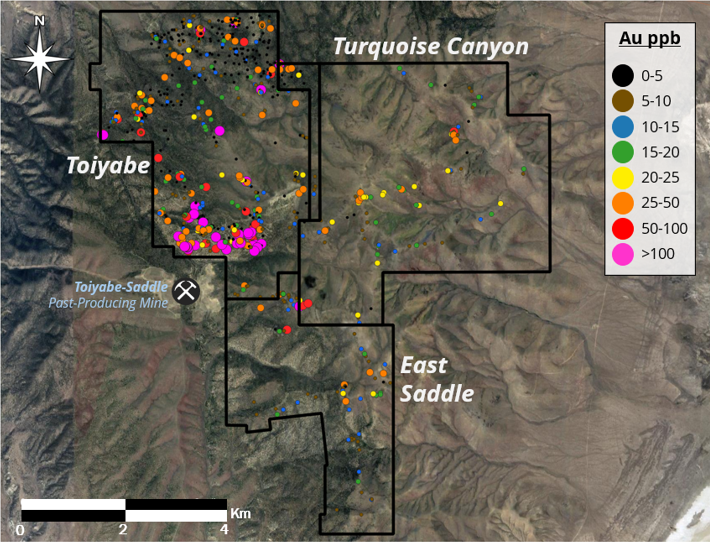
Note: for assay results of rock-chip samples collected by Westward in 2023, please refer to the Company’s press release dated January 18, 2024, for additional technical disclosure and details surrounding sampling methodology, chain of custody, quality assurance and quality control. Source (historical sample results, Toiyabe Project): NI 43-101 Technical Report, IM Exploration Inc., Prepared by Donald E. Cameron, P.Geo, August 5, 2021.
Figure 5: Hilltop Target Area
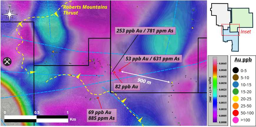
Hilltop Target Area – Details:
- Gold assay values up to 253 ppb in upper-plate siliciclastic rocks
- Arsenic assay values up to 885 ppm; elevated mercury and antimony
- Intersection of east-west gravity structures and the Roberts Mountains Thrust Fault
- Horizontal gradient of gravity shows the maximum rate of change in density, indicative of prospective structures and alteration
- Lies in the same structural corridor as the past-producing Toiyabe-Saddle Mine with elevated pathfinder element assay values
- 900 meters of unsampled ground between samples with elevated gold in outcrop
- Target area has seen no previous drilling
Figure 6: Crossroads Target Area
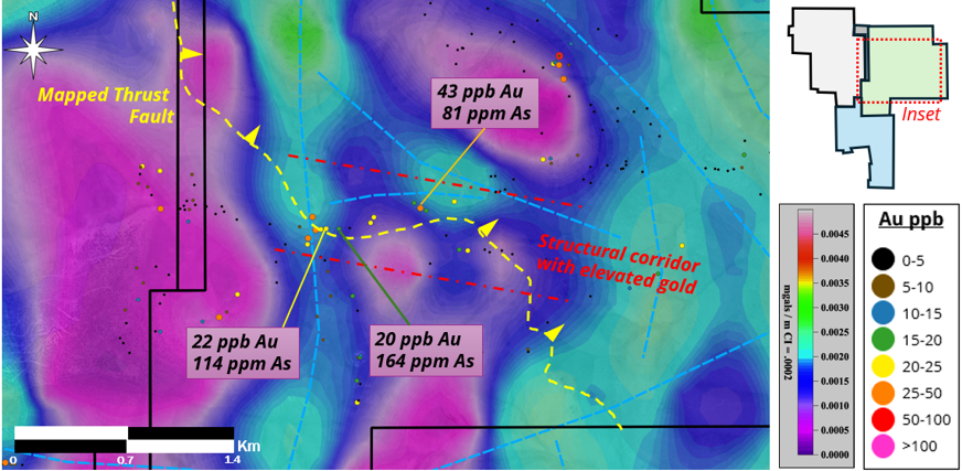
Crossroads Target Area – Details:
- Gold assay values up to 43 ppb in upper-plate siliciclastic rocks, within a structural corridor with anomalous gold values
- Intersection of north-south and east-west gravity structures in the horizontal gradient
- Intersection of gravity structures and mapped thrust fault
- Intense brecciation, folding, and faulting observed in outcrops
- Target area has seen no previous drilling
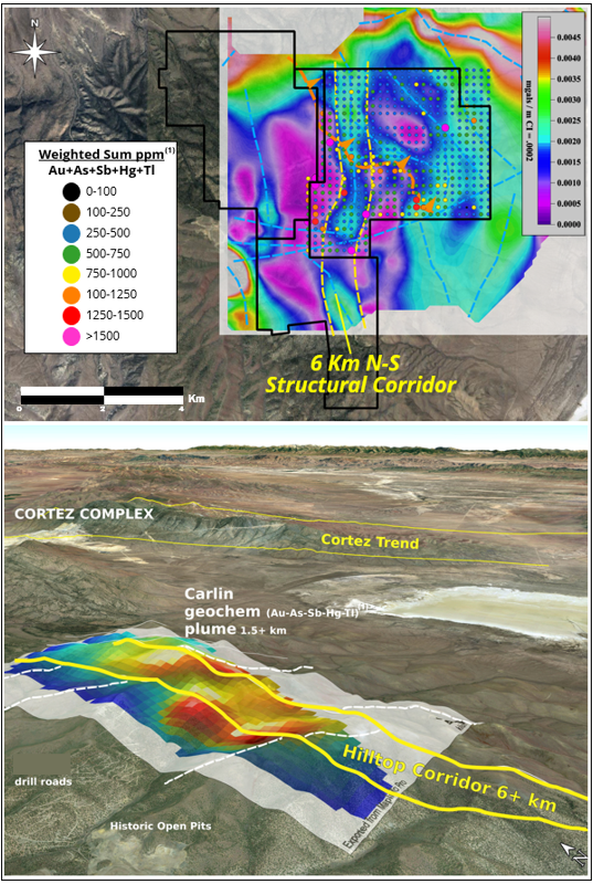
In addition to the expanded rock-chip sampling program, the Company will collect and analyze 850 soil samples at the Properties. Architecture and zonation of soil grid geochemical results are fundamental to understanding the mineralizing system and confirming the best targets. Figure 7 below shows soil sample analysis at the Turquoise Canyon Project, in addition to the regional horizontal gradient of gravity, and structural data which support the emerging Hilltop Corridor area of interest. Figure 8 below shows gold-in-soil assay results at Toiyabe, arsenic-in-soil results at Turquoise Canyon, a soil grid completed in 2023 (Orange) and the planned 2024 survey grid (Purple). The goal of the soil sampling program is to identify fluid-flow vectors and zoned geochemical elements which point towards the highest areas of fluid flux and the most promising lower-plate targets.
Figure 7: Hilltop Corridor Target Area
Source (Turquoise Canyon Project – Soil Geochemical Results): NI 43-101 Technical Report, Westward Gold Inc. (Momentum Minerals Ltd.), Prepared by Scott Close, M. Sc., P.Geo, February 23, 2021.
(1) Weighted sum geochemical modeling: The Company’s technical team has plotted the weighted sum of the classic Carlin gold system element assemblage: Au, As, Sb, Hg and Tl. The methodology involves normalizing the raw data, weighting each element according to relative importance in the overall assemblage, summing these factors, and plotting heat maps. Westward has used a proprietary algorithm in this case, however the general methodology is widely used in gold exploration across the globe. Gold signals are often attenuated in upper-plate rocks due to nonreactive lithologies and presumed distal location from main stage gold deposition. However, the geochemical signal in upper-plate rocks is critically important as a guide to deeper main-stage mineralization in the underlying lower-plate host rocks. To map the highest fluid flux zones in upper-plate rocks, often a weighted sum of soil geochemical anomalies is plotted to enhance specific mineralization type signals.
Hilltop Corridor – Details:
- Horizontal gradient of gravity defines a north-south structural zone > 6 km across the Properties
- Weighted sum of Carlin pathfinder elements in soil samples shows fluid plumes near structural corridors in upper-plate rocks
- Correlation of inferred gravity structures, mapped structures and surface geochemistry
- Additional mapping, surface sampling and geophysics to refine targeting
- Prospective corridor has seen no previous drilling
Figure 8: Soil Sample Results & Planned 2024 Grid Expansion
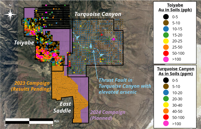
Source (Turquoise Canyon Project – Soil Geochemical Results): NI 43-101 Technical Report, Westward Gold Inc. (Momentum Minerals Ltd.), Prepared by Scott Close, M. Sc., P.Geo, February 23, 2021.
Source (Toiyabe Project - Historical Gold-in-Soil Results): NI 43-101 Technical Report, IM Exploration Inc., Prepared by Donald E. Cameron, P.Geo, August 5, 2021.
Hunting for Carlin-Type Gold Deposits: Expanded Geophysics Programs to Reveal Multi-Million Ounce Potential
Following recommendations given by geophysicist James L. Wright, the Company plans to expand its geophysical database by completing additional gravity and magnetic surveys. Regional geophysical signatures will assist in the identification of potential large, district-scale targets. Reducing the station spacing of historical surveys will allow Westward to identify key gravity gradients related to structure and alteration in finer detail. Magnetic data will help the Company identify and resolve igneous features which have played an important role in the discovery of gold mineralization in the district. Historical magnetic data suggest a possible deep-seated intrusive stock to the northeast of the Properties. Proximity to Mesozoic intrusions is a key element of the most well-endowed Carlin settings, and Eocene intrusive stocks have long been identified as the heat engines which mobilize mineralizing fluids into Carlin-type gold deposits. Consequently, an improved understanding of the intrusive geology at depth will be key to both confirming existing priority targets, and unlocking additional prospective areas.
Qualified Person
The technical information contained in this news release was reviewed and approved by Robert Edie, Vice President Exploration of the Company, who is a Qualified Person under National Instrument 43-101 – Standards of Disclosure for Mineral Projects. Mr. Edie is a Certified Professional Geologist (CPG) through the American Institute of Professional Geologists (AIPG).
About Westward Gold
Westward Gold is a mineral exploration company focused on developing the Toiyabe, Turquoise Canyon, and East Saddle Projects located in the Cortez Hills area of Lander County, Nevada, and the Coyote and Rossi Projects located along the Carlin Trend in Elko County, Nevada. From time to time, the Company may also evaluate the acquisition of other mineral exploration assets and opportunities.
For further information contact:
Andrew Nelson
Chief Financial Officer
Westward Gold Inc.
+1 (604) 828-7027
andrew@westwardgold.com
www.westwardgold.com
The Canadian Securities Exchange has neither approved nor disapproved the contents of this news release. The Canadian Securities Exchange does not accept responsibility for the adequacy or accuracy of this news release.
This news release contains or incorporates by reference “forward-looking statements” and “forward-looking information” as defined under applicable Canadian securities legislation. All statements, other than statements of historical fact, which address events, results, outcomes, or developments that the Company expects to occur are, or may be deemed, to be, forward-looking statements. Forward-looking statements are generally, but not always, identified by the use of forward-looking terminology such as "expect", "believe", "anticipate", "intend", "estimate”, “potential”, “on track”, “forecast", "budget", “target”, “outlook”, “continue”, “plan” or variations of such words and phrases and similar expressions or statements that certain actions, events or results “may”, “could”, “would”, “might” or “will” be taken, occur or be achieved or the negative connotation of such terms.
Such statements include, but may not be limited to, information as to strategy, plans or future financial or operating performance, such as the Company’s expansion plans, project timelines, expected drilling targets, and other statements that express management’s expectations or estimates of future plans and performance.
Forward-looking statements or information are subject to a variety of known and unknown risks, uncertainties and other factors that could cause actual events or results to differ from those reflected in the forward-looking statements or information, including, without limitation, the need for additional capital by the Company through financings, and the risk that such funds may not be raised; the speculative nature of exploration and the stages of the Company’s properties; the effect of changes in commodity prices; regulatory risks that development of the Company’s material properties will not be acceptable for social, environmental or other reasons, availability of equipment (including drills) and personnel to carry out work programs, that each stage of work will be completed within expected time frames, that current geological models and interpretations prove correct, the results of ongoing work programs may lead to a change of exploration priorities, and the efforts and abilities of the senior management team. This list is not exhaustive of the factors that may affect any of the Company’s forward-looking statements or information. These and other factors may cause the Company to change its exploration and work programs, not proceed with work programs, or change the timing or order of planned work programs. Additional risk factors and details with respect to risk factors that may affect the Company’s ability to achieve the expectations set forth in the forward-looking statements contained in this news release are set out in the Company’s latest management discussion and analysis under “Risks and Uncertainties”, which is available under the Company’s SEDAR profile at www.sedar.com. Although the Company has attempted to identify important factors that could cause actual results to differ materially, there may be other factors that cause results not to be as anticipated, estimated, described or intended. Accordingly, readers should not place undue reliance on forward-looking statements or information. The Company’s forward-looking statements and information are based on the assumptions, beliefs, expectations, and opinions of management as of the date of this press release, and other than as required by applicable securities laws, the Company does not assume any obligation to update forward-looking statements and information if circumstances or management’s assumptions, beliefs, expectations or opinions should change, or changes in any other events affecting such statements or information.